
02 August 2012
Ernesto heads for Caribbean, suggesting possible chase.
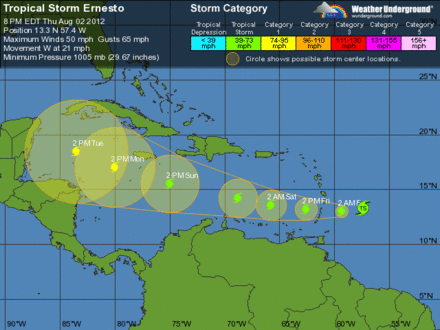
Tropical Storm Ernesto is heading W toward the Lesser Antilles this evening, and it'll cross into the Caribbean Sea by tomorrow. The National Hurricane Center's official forecast shows a strengthening hurricane approaching Mexico's Yucatan Peninsula in five days.
Needless to say, the iCyclone team is on alert! This could get interesting.
Currently, environmental conditions around Ernesto aren't great, as evidenced by the lackluster satellite presentation. However, there are indications that the cyclone will encounter much more favorable conditions in the W Caribbean in a few days—not to mention super-high-octane oceanic heat content. iCyclone right-hand man Scott Brownfield thinks the system may really explode if the upper-air pattern cooperates.
Re: the track... After some "windshield wiping" today, the computer models seem to be generally agreeing on a W or WNW path across the Caribbean, toward Belize or Mexico's Yucatan Peninsula.
This is no slam dunk, like Dean in 2007. Indeed, the two most reliable models—the Euro and the GFS—aren't terribly enthused with Ernesto. That having been said, Mexico's Yucatan Peninsula is Josh Morgerman's favorite chase turf on the planet—practically his second home.
So... We're going to watch this very closely over the next few days.
It's August in the Caribbean. Anything can happen.